One of the not well known features in AutoCAD WS is to place your AutoCAD drawing on top of Google Maps. First for those not familiar with AutoCAD WS we need to bring you up to speed on this free collaboration tool used by hundreds of thousands of people since it’s launch beginning of October 2010.
 AutoCAD WS is available free and only requires a browser such as Safari, IE, Chrome, or Firefox with Flash installed. Now in addition being able to upload, edit, markup, and share in real-time with DWG files, you can also upload other file types like ZIP, Doc, and PDF files as a file storage solution. You can also control who can download or view the drawings.
 There is also AutoCAD WS Mobile free from the Apple iTunes Store http://www.itunes.com/app/autocad-ws. With AutoCAD WS Mobile, you can use the native iOS based AutoCAD WS Mobile on your IPhone, IPod Touch or IPad to view, markup, and edit DWG files uploaded to your AutoCAD WS account. You can even view your drawing offline with the AutoCAD WS 1.1 mobile 1.1 update.
OK back to the Google Map part which only applies to the browser based AutoCAD WS, not the AutoCAD WS Mobile version.
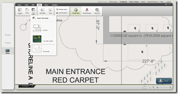
So why would someone want a Google Map to be displayed under their drawing in AutoCAD WS? You could use it to show a building plan over an existing map or structure as I did for Autodesk University 2010. The ability to see a geographic map background can help visualize many things beyond just the location.
In AutoCAD WS under the View menu is the option to place your drawing over a Google Map. You can display the maps in the standard Google Map types Street, Satellite, Hybrid and Terrain.
I first found the location in satellite mode that I wanted to place my drawing over. 
Then I lined up my drawing with the Google Map by drawing a line first on the Google Map underlay feature then drawing a line on the corresponding part of my drawing I wanted it to line up with.


Keep in mind Google Maps satellite, aerial, and map data is not exactly the same 64 bit precision as AutoCAD and that satellite or aerial images will have distortion to them due to their viewing angle/tilt, curvature of the Earth, and vertical topography, but you can match them up quite well.
Here are some images of the Autodesk University 2010 layout in the Mandalay Bay conference center. I typically use the View Mode > Grayscale mode to clearly see all the linework in black and white in my drawing.


Give AutoCAD WS a try, it’s free, and a great way to collaborate with others. There is also no need to install anything to view, mark up, or lightly edit a drawing.
Cheers,
Shaan
It is live referencing the Google Map and not saved to the drawing file. You could always screenshot a raster image if allowed by Googe Map content usage terms..
Regards
Shaan
PING:
TITLE: AutoCAD WS Update Coming Free CAD DWG Viewer
BLOG NAME: Between the Lines
The AutoCAD WS Team is once again teasing us with this posting on their Facebook Page. https://www.facebook.com/#!/AutoCADWS
“First glimpse of the new launch screen for the next release of AutoCAD WS – Coming Soon!“
PING:
TITLE: AutoCAD WS 1.2 Mobile Update
BLOG NAME: Between the Lines
Some nice updates for the FREE AutoCAD WS just went live with AutoCAD WS Mobile1.2. The update 1.2 is now available for download on the Apple iTunes App Store at http://autode.sk/get_acadws_app or from your device.
Did I mention it’s still FREE?
I wish I could zoom in to see the effect. Is it possible to change the transparency, to compare the AutoCAD (design) layer to the current Google map?
I don’t believe this is possible in AutoCAD WS like you can with a raster image in desktop AutoCAD.
is it possible to save part of the google map image from autocad ws?